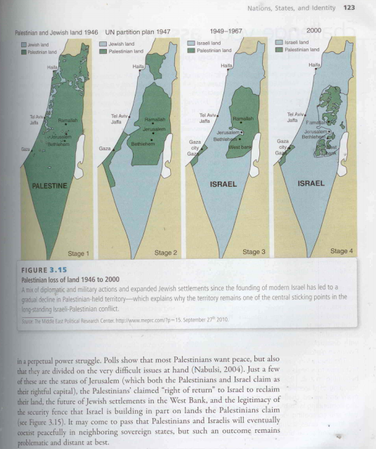
What's new

Maps of Israel/Palestine from 1947-2000

So, what stops Indians ?

ridiculous patience of our state and weak leadership,

Dont wish too much. Last time 1 Pak solider equaled 10 "dirty" hindoos made us lose half of the country.

Time to forget conspiracy theories and fix up out act of we will soon be referred to as "North Korea II".
 
ridiculous patience of our state and weak leadership,

So, who elects this "ridiculously patient weak leadership" ?

Dont wish too much. Last time 1 Pak solider equaled 10 "dirty" hindoos made us lose half of the country.

Time to forget conspiracy theories and fix up out act of we will soon be referred to as "North Korea II".

You will not be here to see, you will be with "Jahil Arabs" transmitting your "Intellectual brilliance".
 
maps of Israel
israel-map.gif

map20middle-east.gif
 
Map by OP is a lie

The first panel of the traditional version of this map has the biggest lie:
mapthatlies2.jpg

While I presume that the white sections are indeed the land that was privately owned by Jews, the land in green was not privately owned by Arabs.

Only a tiny percentage of land in Palestine was privately owned. The various categories of land ownership included:
Mulk: privately owned in the Western sense.
Miri: Land owned by the government (originally the Ottoman crown) and suitable for agricultural use. Individuals could purchase a deed to cultivate this land and pay a tithe to the government. Ownership could be transferred only with the approval of the state. Miri rights could be transferred to heirs, and the land could be sub-let to tenants. If the owner died without an heir or the land was not cultivated for three years, the land would revert to the state.
Mahlul: Uncultivated Miri lands that would revert to the state, in theory after three years.
Mawat (or Mewat): So-called “dead”, unreclaimed land. It constituted about 50 to 60% of the land in Palestine. It belonged to the government. ...If the land had been cultivated with permission, it would be registered, at least under the Mandate, free of charge.

By the early 1940s Jews owned about one third of Mulk land in Palestine and Arabs about two-thirds. The vast majority of the total land, however, belonged to the government, meaning that when the state of Israel was established, it became legally Israel's. (I believe that about 77% of the land was owned by the government, assuming 6 million dunams of private land as shown in this invaluable webpage on the topic from which I got much of this information.)

To say that the green areas were "Palestinian" land is simply a lie.


In the case of this version of the map, the lie is even worse, as the implication is that pre-1948 Palestine was an entirely Arab country with no Jews and no Jewish land ownership. Of course, before 1948 the word "Palestinian" more often than not referred to Palestinian Jews, not Palestinian Arabs. For example, the Palestine exhibit at the 1939 World's Fair was entirely Jewish, the Palestine Orchestra was entirely Jewish, the Palestine soccer team was almost entirely Jewish, and so forth.

Now the next one:
mapthatlies3.jpg

While this is a somewhat accurate representation of the partition plan (with the notable exception of Jerusalem, which was meant to be an international city,), it has nothing to do with land ownership. The entire purpose of this map is to make it appear that Israel has been grabbing Arab land consistently, to serve as a bridge between maps 1 and 3. What is not said, of course, is that Israel accepted the partition and the Arabs did not, so as a result Israel in 1949 looked like it does in map 3.

Map 3 is still a lie, however, because in no way was the green land "Palestinian" at that time. Gaza was administered by Egypt and the West Bank annexed by Jordan. No one at the time spoke about a Palestinian Arab state on the areas controlled by Arab states - only in Israel.

In other words, this progression of maps is a series of lies meant to push a bigger lie, and it is tragic that a lot of people believe them to be the truth.

Here is a small attempt on my side to show a more accurate picture of Israel's giving land it controlled up for peace since 1967:
Israeli+land+concessions.jpg

This map shows that Israel gave up control of the Sinai, Gaza, Southern Lebanon and much of the West Bank over the years. Rather than falsely accusing Israel as a land-grabbing rogue state, it accurately shows Israel as perhaps the only state in history that has voluntarily given up more than two-thirds of the areas it controls in exchange for nothing more than a paper agreement - or sometimes not even that. All at the risk of serious security concerns for her people, no less.

This is all because Israel wants, desperately, to live in real peace with her neighbors. This desire is not reciprocated by those neighbors, unfortunately.

The real map shows the truth of Israel's incredible concessions in the often vain hope for peace.
 
And who's fault is that?

it's not a fault ... we are not a security state to begin with, it was fortunate that we had a leader like Indira Ji who had fierceness, current governments are coalitions between 34 parties, decisions are weighed and argued upon a million times before taking them. Our policy makers are are more afraid of the stock markets plunging than loosing 250 lives in a metropolitan city. Maybe modi is the solution! lets see.
 
What's wrong in it? Can you please explain.

This map is not the territories

A FEW days ago Andrew Sullivan published a rather distorted map that misrepresents the history of land transfers from Palestinian to Jewish control in the territory of Israel and Palestine. It's not clear who initially produced the map, but Mr Sullivan got it from Juan Cole, the Middle East expert, who should have known better. Jeffrey Goldberg strongly objected to the map, but he did a poor job of explaining why the map is so confused and tendentious. Mr Sullivan then responded to Mr Goldberg's objections in a fashion that, because those objections were not well explained, also missed the point.

It's a big mess. Here's the map in question:

PalestineIsraelMap580.jpg


Mr Goldberg argued that the problem with this map is that it represents the territory in 1946 under the name "Palestine", implying that there had been a Palestinian state which was then taken over by Israel. But that's not quite the point. The point is that the map fails to distinguish between land that is owned by Jews or Palestinians, and land that is controlled by Jewish or Palestinian political entities.

Take the vast triangular tract of land at the south of the map. That's the Negev desert. Apart from a few small oases, kibbutzes and towns, it's empty wasteland; it isn't owned by anyone. It represents almost half of the territory of Israel/Palestine. In 1946, the map represents it as "Palestinian land". That's silly. In 1949, it has somehow become "Jewish land". That's almost as silly, though Jewish irrigation projects did gradually, over a period of decades, turn an increasing (if still-small) portion of the desert into arable agricultural land claimed by Jewish owners. But the impression the map gives is that in 1947-8, Jews seized that land from Palestinian owners, which is absurd. What happened was that a piece of empty desert which had been under the control of the British Mandate (who got it after the Ottoman Empire fell apart) was awarded to the Jewish state. This is a question of political control, not land ownership.

Here's an even more obvious case. See that rightward bulge at the map's top right? In 1946, it too is green, and by 1949, it too has turned white. That bulge is the Sea of Galilee. It seems fairly straightforward that representing this body of water as "Palestinian land" in 1946 and "Jewish land" in 1949 is rather absurd.

Even within settled areas, like the coastal plain, the Galilee and the West Bank, it's impossible to tell from this map whether "Jewish land" refers to land owned by Jews or land under Israeli/Jewish political control. What about land that continues to be owned by its Palestinian owners while politically becoming part of Israel? Such land is not represented on this map. And so forth. The map needs to distinguish four categories of land: land owned by Jews under Israeli political control; land owned by Jews but under Palestinian political control; land owned by Palestinians but under Israeli political control; and land owned by Palestinians under Palestinian political control. On the 1946 map, furthermore, there would need to be a different means of representation entirely, since there was, at the time, no Jewish or Palestinian political control. This map blurs the distinctions incomprehensibly, and it does so in a way that tendentiously maximises the impression that Jews have seized Palestinian-owned land.

Jews, and the Israeli state, have, in fact, seized great quantities of Palestinian land in the territory of Israel/Palestine over the past 60 years. Israelis and Americans must acknowledge this fact to make any progress towards peace, and an accurate accounting of such seizures would be very valuable. But this particular map only confuses and distorts the issue, and seems clearly designed for propaganda purposes.

Israel and Palestine: This map is not the territories | The Economist
 
Even better explained:

The maps of disappearing Palestine

By Yaakov Lozowick

Anyone who deals with the Israel-Palestine conflict will probably have come across the nasty four-map series purporting to show how Israel is eliminating Palestine step by step. Recently some fellow in the NY area hired space on local billboards to expose them to commuters. I contacted him and asked if he’d be willing to listen to a critique; when he said he would I sent him the following analysis. You can see his brief response – and mine – at the end.

According to what I’ve read on Mondoweiss, you seem to be of the opinion that the series of four maps showing the disappearing Palestinian presence in what was once Mandatory Palestine are factually accurate. I suggest we take a closer look.


PalestinianLossOfLand_poster.jpg


There are various problems with the series, the most obvious being that it compares apples with oranges and also with screwdrivers, meaning that the different maps present different data-sets. Some of the data-sets themselves are inaccurate.

Judging by the picture above, your version of the maps is even more problematic than some of the other versions which are out there. I’ll relate to your version as presented on Mondoweiss.

First, the map from 1946. Even standing alone without the series, it’s misleading in that it contains two distinct types of information. The outline is of the territory controlled by the British, commonly known as Palestine. Being a map of a political entity, however, the whole thing should be the same color, green in this case, since the entire territory was ruled by the British, the white parts and the green. If one wished to show privately owned land under the sovereignty of the British according to ethnic identity, the green would have been replaced by a hodgepodge of colors. Some of the land was owned by Jews, some by Arabs (today we would call them Palestinians), some by Arab absentee landlords of other nationalities (Lebanese, Syrians, Egyptians and so on), some by European churches – Catholic Protestant, Greek Orthodox, Russian Orthodox and others, and finally, the largest section by far would have been land registered by no-one and thus belonging to the government, i.e the British.

As far as I can see, your version has omitted the Jewish ownership of property in Jerusalem (where there was a majority of Jews), and in various pockets such as the Etzion Block, Neve Yaacov, settlements on the Dead Sea, Hebron, Safed, Naharia and its hinterland, Kfar Darom in Gaza, and so on. But the main problem with this map isn’t its omissions of Jewish property, but rather the implication that any land not owned by Jews was “Palestine”. Not true. If it’s land ownership you’re trying to depict then most of the territory was owned by the British government; if it’s political sovereignty then the entire area was British.

The second map drops the issue of land ownership, and the series never returns to it. This map is a reasonably accurate depiction of the partition plan adopted by the United Nations on November 29th 1947, with one glaring omission: the Jerusalem-Bethlehem area, which was very clearly not allocated to either side, but designated as a Corpus Separandum. I emphasize: Jerusalem and Bethlehem. So the cartographer has allocated to a notional Palestine a very important piece of territory which it never had.

Of course, this map never depicted a reality. At the time it was rejected by all the Arab states which had a vote, and also by the local Arabs themselves who did not generally call themselves Palestinians at the time, but we can agree to call them that now. I’m not going to get into the question of who foiled the UN partition plan, but I think we can agree that all sides played their roles; the Jewish Yishuv, Husseini’s Palestinian forces, Kaukji’s forces, and the Egyptian, Jordanian, Syrian, Iraqi and Lebanese forces which participated in fighting in territory which had previously been under British rule.

The third map (1949-1967) is misleading in its own way. It depicts Israel in white, and two other un-named territories in uniform green, the same green the first two maps implied had been Palestinian territory. Of course, this does not conform to the historical reality. The Gaza section was controlled by Egypt, not the Palestinians, and rightfully should be defined as Egyptian-occupied Gaza. The larger green section was controlled by Jordan. Jordan annexed it and gave its population Jordanian citizenship, so I don’t know if it was legally occupied or not: if so, it’s status was probably similar to its status under Israeli rule after 1967: occupied, with settlers from the occupying country. If it wasn’t occupied, then it was part of Jordan. (That’s the source of the name “West Bank: the western half of Jordan). Either way, it can’t be depicted as Palestine.

You’ll also note that this map shies away from dealing with private ownership, which was the theme of the first map. Had it shown private ownership it would have had to note that some of the territory inside Israel was owned by Palestinians, of course, but that no land inside Jordan was accepted as being owned by Jews, even though in some places their ownership had never been rescinded in anything that might resemble due process.

I suppose you may say I’m quibbling, and that in a territory which had a minority of Jews 150 years ago, there has emerged a state of foreigners which has thwarted the emergence of a state of the original population. This, of course, is true. The tragedy of the Israeli-Palestinian conflict is that both sides are right, and both have legitimate claims on the same tiny piece of land. Most of us think that the only way to resolve the conflict is for each side to reconcile itself to the loss of important parts of the territory so that the other side will have room for their national state. As to why this hasn’t yet happened, you and I probably disagree. We may also not agree on the details of how the partition ought to be done. Yet those are legitimate issues which need to be resolved in negotiations.

The maps you’ve published, on the other hand, tell a different story: that Israel is purposefully pushing out the Palestinians so as to have the entire land for itself. This is not true, which explains why in order to make the claim the maps need to be so sloppy with the facts.


(.........)

The maps of disappearing Palestine (Yaakov Lozowick) » Israel-Palestina Info ~ Actueel
 
Dont wish too much. Last time 1 Pak solider equaled 10 "dirty" hindoos made us lose half of the country.

Time to forget conspiracy theories and fix up out act of we will soon be referred to as "North Korea II".

The reason was some thing else you know that.
 
Jews from all over the world were shipped to Palestine after the British empire took it over after the first world war. Before that there was no such thing as Israel. Israeli claim is that "this is our land because we lived here 2000 years ago". Even though most of the Israelis are European American descent, the land belongs to Palestinians, they are the people of the land who converted to Islam- contrary to what Zionist apologist media would have us believe. . Hinus support Israel only because anything anti muslim serves their nerves.

wat do hindus have to do with your self imposed war against jews. most of indian including other religions support isreal bcoz they have shown world how to survive when u r surrounded by enimes all around. a great nation they never beged for freedom they snached for barbaric muslim nations
 
new%2Beoz%2Blogo3.png

Sunday, March 06, 2016
FULL VICTORY: McGraw-Hill rules politics textbook is wrong, will destroy all copies and issue refunds

I exposed a college textbook, "Global Politics: Engaging a Complex World", that included The Map That Lies anti-Israel propaganda picture.


A number of people wrote to complain to the publisher, McGraw Hill, and to its credit, within a day the company said that they put all sales on hold pending review.


That review has apparently been completed over the weekend, and the book is being pulled from distribution and existing copies destroyed.. Mark Jacobs received this reply from the company on Sunday evening:

Thank you for your query about the map in Global Politics: Engaging a Complex World. As soon as we learned about the concerns with it, we placed sales of the book on hold and immediately initiated an academic review. The review determined that the map did not meet our academic standards. We have informed the authors and we are no longer selling the book. All existing inventory will be destroyed. We apologize and will refund payment to anyone who returns the book.

Kind Regards,
Paula O | Customer Service Representative | Customer Service
School Education, Higher Education, Professional
McGraw-Hill Education | 860 Taylor Station Road Blacklick, OH 43004

At the moment, the book is still on sale at many textbook and bookseller sites, although it was pulled immediately from the McGraw-Hill website. But I assume that is an issue of logistics.

Kudos to McGraw-Hill for working to resolve this quickly and professionally. They took this very seriously and really went above and beyond to reach an accurate conclusion and make this decision - on a weekend!

Send your thanks to McGraw-Hill customer service hep_customer-service@mheducation.com and to their Twitter account @mhhighered and @mheducation.

I am very happy that this blog was able to make a difference. If only all media would be as responsive as McGraw-Hill has been to being shown that they are disseminating inaccurate anti-Israel information.
 
These maps are fake , still israel owns the desert and palestinian the better climated parts , that's why the israeli soldier is so lean , they have to climb the height to reach the west bank neighborhoods

israel is done , like i said in the 80s they took part in the lebanese civil war on behalf of the united states , now with the syrian civil war all they can do is to sit and watch , or maybe carry a few airstrikes to take out hezzy commanders , 30-40 years from now israel will cease to exist
 
Torah says the the holy land expands from the river Euphrates to the river of Egypt (Nile). Expect Israel to expand to fulfill the biblical frontiers. There's a reason there is a huge proxy war in the ME right now.
 
Torah says the the holy land expands from the river Euphrates to the river of Egypt (Nile). Expect Israel to expand to fulfill the biblical frontiers. There's a reason there is a huge proxy war in the ME right now.
Torah says a bunch of other lies too , it says to "take slaves from neighboring nations" while juice has always been slaves and untermensch themselves , today they are nothing more than american slaves , or pundits if you will
 

Back
Top Bottom